Datei:Kaliningrad, Baltic Sea, Russia.JPG

Aus Klexikon - Das Freie Kinderlexikon
Wechseln zu: Navigation, Suche
Volle Auflösung(4.256 × 2.832 Pixel, Dateigröße: 8,88 MB, MIME-Typ: image/jpeg)

Diese Datei stammt aus Wikimedia Commons und kann von anderen Projekten verwendet werden. Die Beschreibung von deren Dateibeschreibungsseite wird unten angezeigt.

Beschreibung

Beschreibung
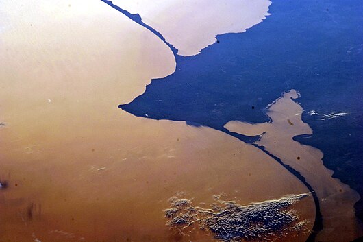
English: This photograph from the International Space Station captures two great lagoons to the north and south of Kaliningrad, Russia. The dark blue features are land. The beige mass at the top and the beige mass in the lower right are the lagoons. The largest mass of beige is the Baltic Sea. From an astronaut’s perspective in low-Earth orbit, land surfaces usually appear brighter than water. But in this image, reflected sunlight, or sunglint, inverts this pattern. The light has a coppery hue, perhaps due to smog particles in the air, which enhance the red part of the spectrum.

The camera settings used to acquire sunlint images result in high contrast, which reveals the fine detail of coastlines and surface features of water bodies, while masking land surface details. The thin, 50 kilometre barge canal leading from the Baltic to Kaliningrad is visible, but the great port of Kaliningrad itself is not. Other human patterns on this intensively developed landscape—such as towns, highways and farm boundaries—are likewise masked.

The area has a long human history. The growth of the Vistula spit finally cut off the north Polish city of Elblag (just beyond the bottom of the image) from the Baltic Sea in the 13th century. To reconnect Elblag with the Baltic Sea, the European Union is considering whether to fund the creation of another canal through the spit at image lower right, despite ecological concerns.
Datum
Quelle NASA Earth Observatory
Urheber ISS Expedition 28 crew
Kameraposition55° 00′ 00″ N, 19° 42′ 00″ O Kartographer map based on OpenStreetMap.Dieses und weitere Bilder auf OpenStreetMapinfo
Diese Mediendatei wurde vom Johnson Space Center der US-amerikanischen National Aeronautics and Space Administration (NASA) unter der Datei-ID ISS028-E-24146 kategorisiert.

Diese Markierung zeigt nicht den Urheberrechtsstatus des zugehörigen Werks an. Es ist in jedem Falle zusätzlich eine normale Lizenzvorlage erforderlich. Siehe Commons:Lizenzen für weitere Informationen.
Sprachen:

Image acquired with a Nikon D3S digital camera using a 400 mm lens, and is provided by the ISS Crew Earth Observations experiment and Image Science & Analysis Laboratory, Johnson Space Center.

Lizenz

Public domain Diese Datei ist gemeinfrei (public domain), da sie von der NASA erstellt worden ist. Die NASA-Urheberrechtsrichtlinie besagt, dass „NASA-Material nicht durch Urheberrecht geschützt ist, wenn es nicht anders angegeben ist“. (NASA-Urheberrechtsrichtlinie-Seite oder JPL Image Use Policy).
Warnung:
Bildnotizen
InfoField
Diese Datei ist annotiert: Betrachte diese auf Commons.

Kurzbeschreibungen

Ergänze eine einzeilige Erklärung, was diese Datei darstellt.

In dieser Datei abgebildete Objekte

Motiv

55°0'0.000"N, 19°42'0.000"E

0,0005 Sekunde

400 Millimeter

Dateiversionen

Klicke auf einen Zeitpunkt, um diese Version zu laden.

Version vomVorschaubildMaßeBenutzerKommentar
aktuell13:25, 22. Aug. 2011Vorschaubild der Version vom 22. August 2011, 13:25 Uhr4.256 × 2.832 (8,88 MB)Originalwana{{Information |Description ={{en|1=This photograph from the International Space Station captures two great lagoons to the north and south of Kaliningrad, Russia. From an astronaut’s perspective in low-Earth orbit, land surfaces usually appear

Keine Seite benutzt diese Datei.